
|
|
Product Description
A 2016 Notable Social Studies Trade Book for Young People (National Council for the Social Studies-Children's Book Council)
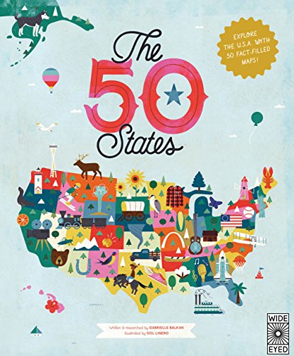
In 51 charmingly illustrated infographic maps, explore every state of the USA from Alabama to Wyoming and the nation’s capital to discover more than 2,000 facts that celebrate the people, cities, nature, and historic events that have helped make America what it is today. You'll also get an expansive guide to the state flags and US presidents.
Ghost towns, swamp tours, the center of the universe…bacon donuts, brainy berries, salmon jerky…The French Fry King, The Mother of Oregon, The Queen of Blues…be inspired by the inventiveness, beauty, and diversity of the United States in this curious collection of fact-filled maps.
On each wonderful map, find:
- A welcome box with a short introduction to the state
- Key facts, including the capital; state bird, flower, and tree; and statehood order
- State icons celebrating the state’s people, places, and history
- Six inspiring people who have a connection to the state
- Region spotlight bubbles to allow you to discover more about one particular place
- A moments to remember box with a list of significant dates and their events in the state’s history
Each state’s map also contains information about which states it neighbors, its bodies of water and borders, as well as where it is situated in the country. Did you know that while Hawaii shares its border with no one, both Missouri and Tennessee border eight other states? Many state parks, battlefields, national forests, and reservations are also included to inspire you to respect and explore the great outdoors.
So pack your bags and say later ‘gator…the great States await!

Customers Who Bought This Item Also Bought
- National Parks of the USA
- Everything & Everywhere: A Fact-Filled Adventure for Curious Globe-Trotters (Travel Book for Children, Kids Adventure Book, World Fact Book for Kids)
- Atlas of Adventures: A collection of natural wonders, exciting experiences and fun festivities from the four corners of the globe
- The Travel Book: A journey through every country in the world (Lonely Planet Kids)
- Maps of the World: An Illustrated Children's Atlas of Adventure, Culture, and Discovery
- Maps
- The 50 States: Activity Book: Maps of the 50 States of the USA
- The 50 States - Flashcards
- The 50 States: Fun Facts: Celebrate the people, places and food of the U.S.A!
- 50 Cities of the U.S.A.: Explore America's cities with 50 fact-filled maps (The 50 States)
*If this is not the "The 50 States: Explore the U.S.A. with 50 fact-filled maps!" product you were looking for, you can check the other results by clicking this link


