Enjoy fast, free delivery, exclusive deals, and award-winning movies & TV shows with Prime
Try Prime
and start saving today with fast, free delivery
Download the free Kindle app and start reading Kindle books instantly on your smartphone, tablet, or computer - no Kindle device required.
Read instantly on your browser with Kindle for Web.
Using your mobile phone camera - scan the code below and download the Kindle app.


Book recommendations, author interviews, editors' picks, and more. Read it now.


Customers who viewed this item also viewed
Page 1 of 1 Start overPage 1 of 1


![Pacific Crest Trail [Map Pack Bundle] (National Geographic Trails Illustrated Map)](https://images-na.ssl-images-amazon.com/images/I/71eTpv-y3aL._AC_UL160_SR160,160_.jpg)


From the Publisher


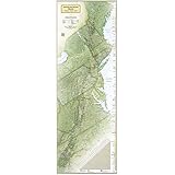
National Geographic’s Long Distance Trail wall maps – A beautiful way to commemorate hiking achievements
Established by the U.S. Congress in 1968, the National Scenic Trail System includes 11 of the nation’s top hiking trails. Among these, 3 trails rise to the level of the iconic and are known for their history, difficulty, and outstanding beauty. The Appalachian Trail, Pacific Crest Trail, and Continental Divide Trail are hiking’s crown jewels. These trails are visited and hiked by millions of people each year and showcase some of America’s most scenic natural wonders. Featuring National Geographic’s renowned cartographic style and attention to detail, these long distance trail maps are the perfect products to commemorate a hiking achievement or to simply add a beautiful element to your home or office décor. The maps are printed on high-quality poster stock and are presented as a vertical image that measures 18" x 48". Each map has a trail elevation profile along the edge that shows the peaks and valleys along the way.

|

|

|

|
|
|---|---|---|---|---|
| Appalachian Trail Wall Map | Pacific Crest Trail Wall Map | Continental Divide Trail Wall Map | Triple Crown of Hiking set of all 3 Wall Maps | |
|
|
|
|||
| Customer Reviews |
442
|
425
|
74
|
58
|
| Price | — | $19.95 | — | $39.99 |
| Length | 2,190 miles | 2,650 miles | 3,100 miles | 8,000 miles |
| Highest Point | Clingmans Dome 6,643' | Forester Pass 13,153' | Grays Peak 14,278' | - |
| Total Number of Hikers | 2–3 million yearly | 1 million yearly | ||
| Thru-Hikers who have completed entire trail | 20,000 | 7,500 | fewer than 1,000 | fewer than 500 |


Your Purchase Has Purpose
Every purchase helps support the National Geographic Society, an impact driven, nonprofit organization with global reach that uses the power of science, exploration, education, and storytelling to illuminate and protect the wonder of our world.
Reviews with images


Nice map. Looks good on a wall.
Great map especially if you're a long distance hiker. I bought the maps for the triple crown (mainly for memories of the PCT, and goals for the other 2. Good details on them, with stats. Looks great on a wall, and probably even better framed. Will update after I do so, but that's a lot of frame at this size...
Top reviews from the United States
There was a problem filtering reviews right now. Please try again later.


Reviewed in the United States on January 14, 2020


Very nice map, I had bought the puzzle previously thinking I would be able to see a lot of detail, but it was too small. But this is large enough to see the detail I wanted. I attached it to the wall with metal plates and very strong magnets so I can easily remove it to look at it more closely and under magnification, if necessary. Good quality and I’m very pleased with this purchase.
Images in this review

Reviewed in the United States on March 10, 2021
Great map especially if you're a long distance hiker. I bought the maps for the triple crown (mainly for memories of the PCT, and goals for the other 2. Good details on them, with stats. Looks great on a wall, and probably even better framed. Will update after I do so, but that's a lot of frame at this size...
Images in this review

Reviewed in the United States on March 25, 2017

Reviewed in the United States on February 10, 2018
Reviewed in the United States on January 21, 2020

Top reviews from other countries
Terry Wiseman
Pacific Crest Trail wall map - like the trail itself, it's long!
Reviewed in Canada on March 7, 2023
Caressa
Status bezorgd maar Nooit ontvangen en geen reactie van verkopende partij
Reviewed in the Netherlands on December 26, 2021MICHEL Estelle
parfait pour une vision synthétique
Reviewed in France on May 3, 2020
